GeoMax Zoom90R A10, 2″ Robotic Total Station with Surveyor 2 Data Collector

$9,895.00

Geomax Zoom90R 2″ A10 Robotic Total Station in excellent condition. Kit includes a Carlson Surveyor2 Data Collector with SurvCE v. 5 that is equipped with Total Station and Robotics software modules. The Carlson software is sold as-is because it cannot be upgraded or officially registered or transferred.

Dramatically minimize the time of any survey task and boost your performance and accuracy to the maximum. Zoom90 is the ultimate one-man system with up to 20% more automation performance, extended reflectorless measurement capability, STReAM360, accXess technologies and Windows CE open connectivity. Because a perfect solution is more than its single components, the Zoom90 seamless integration makes it the ultimate solution.


Out of stock

Product Description

Principal features:

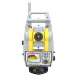
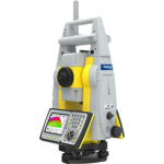
STReAM360: FULLY ROBOTIC 

Scout:    Scans the entire working area within seconds to quickly find the target.
Track:    Continuously track targets. Once locked onto, the instrument remains accurately aimed on the moving target.
Aim:    Aims accurately at any prism, without needing to look through the telescope. Measurements are performed automatically with consistently high and repeatable dependability.

X-MOTION™ HYBRID DRIVES
Zoom90 incorporates highly innovative X-motion hybrid drives, promoting automation performance compared to conventional drives. It will follow your target at 90 km/h at 100 m distance.

accXess™ EDM TECHNOLOGY
GeoMax’s accXess EDM Technology provides leading refl ectorless measurements up to 1000 m.
The extra small laser footprint and the sophisticated signal-processing technology, ensure you accuracy – regardless of the distance or conditions.

NavLight™
Fitted as standard in the telescope, the NavLight is an efficient alignment aid, helping to speed up work while setting out. Its flashing red and yellow lights will guide you quickly and exactly to the line of sight.

FULL CONNECTIVITY
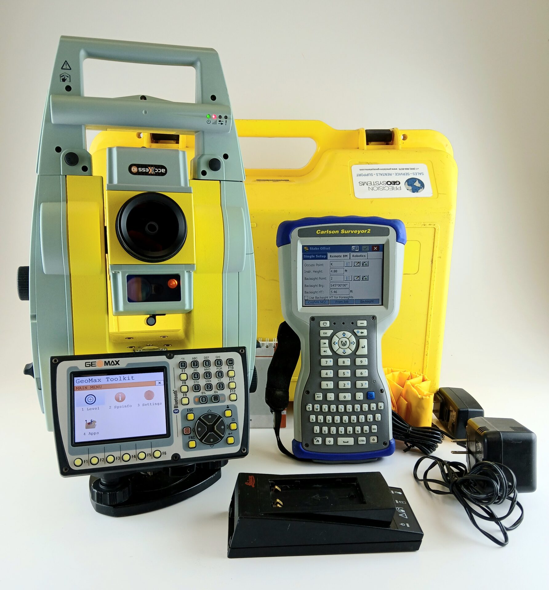
Zoom90 meets all your connectivity needs. Use its built-in Bluetooth® for medium range data transfer or its Bluetooth® handle for high performance long range Bluetooth®. Either way, it is ideal for one-man robotic surveys. Store data on Zoom90’s extra large internal memory, on the removable SD card or the USB stick using plug and play technology.

ROBUSTNESS
GeoMax instruments are built to withstand the toughest conditions. The Zoom90 has been designed and tested to be dust-proof and fully protected against water jets.

OPEN CONNECTIVITY
Combine your preferred software and datalogger to perform remote control tasks with increased productivity. Zoom90 uses the Windows CE operating system, which enables a variety of powerful field software to be run, offering you freedom to choose software that best suits your needs. Full VGA colour-touch display will also provide you with superior performance and full graphic capability.

UPN 650

45 day warrantee provided.

Free shipping to the lower 48.


This Kit Includes:

  • Zoom90 R A10 2″ Fully Robotic WinCE Total Station with AiM360, TRack360 and Scout360, 2″, accXXess10 EDM, NavLight, Alphanumeric Keyboard with VGA Color & Touch Display, Long Range Bluetooth Handle Interface, Internal Bluetooth, USB Port, SD Card Slot, Quick Guide .
  • Zoom90 CD and Quick Start Guide
  • Used Leica GEB 2222 Battery
  • 1GB SD card
  • Charger
  • USB cable
  • Tribrach without optical plummet (black)
  • Long-range Bluetooth handle
  • Rain Cover
  • Geomax Hard Case
  • Carlson Surveyor2 Data Collector with SurvCE v.5 software that includes Total Station and Robotics modules (sold as-is)
  • Charger for Data Collector
  • Data cable (USB) for Data Collector
  • Hard case for Data Collector


Specifications

ANGLE MEASUREMENTS

Accuracy:    1” (0.3 mgon), 2” (0.6 mgon), 5” (1.5 mgon)
Display resolution:    0.1” (0.1 mgon)
Method:    Absolute, continuous, diametrical
Compensation:    Quadruple axis

DISTANCE MEASUREMENTS – PRISM

Range:   Standard mode
Accuracy:   3500 m / 1 mm + 1.5 ppm / typ. 0.8 sec* (fast mode)
Time:   Long mode >10,000 m / 5 mm+2 ppm / typ. 2.5 sec

DISTANCE MEASUREMENTS – REFLECTORLESS
Range:   accXess5: 500m/ accXess10: 1000m
Accuracy:   2 mm + 2 ppm (> 500 m: 4 mm + 2 ppm)
Time:   typ. 3 sec
Precise capture:    8×20 mm at 50 m


MOTORIZATION

Technology:    Hybrid Drives
Scout
Range:    300 m at round prism
TRack
Range:    800 m at round prism
Max speed:    90 km / h at 100 m
AiM
Range:    1000 m at round prism
Hz/V accuracy:    2”
Technique:    Image processing

NavLight ™
Range:   5 m at 150 m
Accuracy:   5 cm at 150 m

INTERFACE

Keyboard:    Two full alphanumeric; 35 keys; illuminated (2nd optional)
Display:    Full VGA 640 x 480 colour and touch with LED backlight
Data recording:    1 GB internal memory; removable SD card and USB stick
Ports:    Serial; USB; internal Bluetooth; longrange Bluetooth handle and external power
Operating system:    Microsoft Windows CE 6.0

PHYSICAL SPECIFICATIONS
Weight:    5.0 – 5.3 kg (w/o battery and tribrach)
Operating/storage temperature:   – 20°C to 50°C / -40°C to +70°C
Protection class:    IP55 dust and waterproof rating
Humidity:    95%, non-condensing

POWER SUPPLY
Internal battery:    Removable Li-Ion 4.4 Ah / 7.4 V
Operating time:    7-10 h (Single measurement every 30 second
at 25° C. Battery time may be shorter depending on conditions.)

PLUMMET
Type:    Laser point, adjustable brightness
Accuracy:    1.5 mm at 1.5 m instrument height